Awaiting location
Temperature, wind, humidity, and present weather will appear here.
A curated operational dashboard for radar, satellite, severe weather, tropical weather, model guidance, and forensic/historical weather research.
Use your device location or enter a city, state, or U.S. ZIP code. The tool uses official National Weather Service forecast data when available.
Enter a location or use your device location to load current conditions.
Temperature, wind, humidity, and present weather will appear here.
This interactive Windy map is centered on the Tampa Bay region with the HRRR CONUS precipitation/thunder layer selected. Use it to review short-range rainfall and thunderstorm timing, then open the full Windy view when you need more controls.
Use these quick links for hurricane monitoring, severe weather, surface analysis, excessive rainfall, climate outlooks, tides, space weather, and heat risk.
Monitor tropical development, severe-weather risk, rainfall, radar, satellite, marine conditions, humidity, wind, climate signals, and space-weather products from trusted operational sources.
Track tropical development, Atlantic satellite structure, sea-surface temperatures, shear, and tropical hazard signals.

NHC 7-day Atlantic tropical outlook.

NHC 7-day East Pacific outlook.

GOES-East Tropical Atlantic sector.
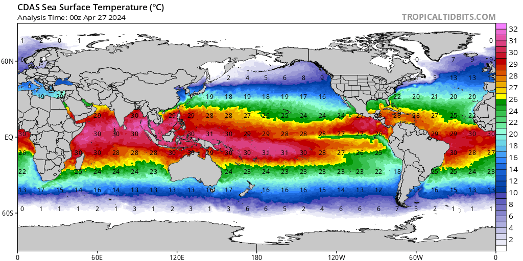
Sea-surface temperature analysis.

Sea-surface temperature anomaly.

Atlantic sea-surface temperature.

Atlantic vertical wind shear.

Global tropical hazards outlook.
Use official SPC links for outlook pages, while the visible tiles below focus on SPC products that display reliably.
Monitor national rainfall, excessive-rainfall risk, surface boundaries, and drought status.
Scan radar loops and GOES-East satellite products that have been loading properly.

National radar loop.

KTBW radar loop.

KAMX radar loop.

KMLB radar loop.

GOES-East CONUS GeoColor.

GOES-East infrared.

GOES-East water vapor.

GOES-East Southeast sector.
Use these products for temperature, humidity, wind, waves, climate outlooks, and teleconnection context.

NWS maximum-temperature forecast.

NWS minimum-temperature forecast.
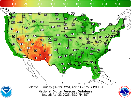
NWS relative humidity forecast.
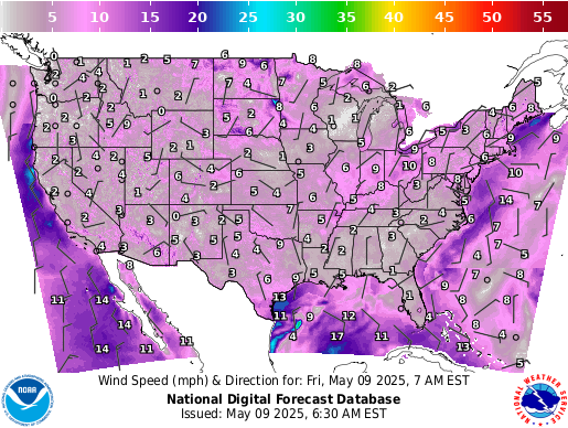
NWS wind-speed forecast.
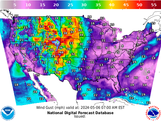
NWS wind-gust forecast.

Atlantic significant wave height.

Gulf significant wave height.

AO index forecast.

North Atlantic Oscillation forecast.

CPC temperature outlook.

CPC precipitation outlook.

CPC temperature outlook.

CPC precipitation outlook.
Follow geomagnetic activity and aurora-related products.
The operational center brings together the kinds of tools used to monitor current conditions and research historical weather events.


